
Inside the Biggest Upgrade Yet to the Swell Intel Forecast Engine
Every surf forecast you read is really an answer to one question: what happens to open-ocean swell in the last few miles before it breaks? The wind builds the swell thousands of miles away, but the seafloor decides what shows up at your beach. This month we shipped the largest set of upgrades to the Swell Intel forecast engine since launch — and almost all of them come down to modeling that last few miles far more honestly.
Seeing the seafloor at 1-meter resolution
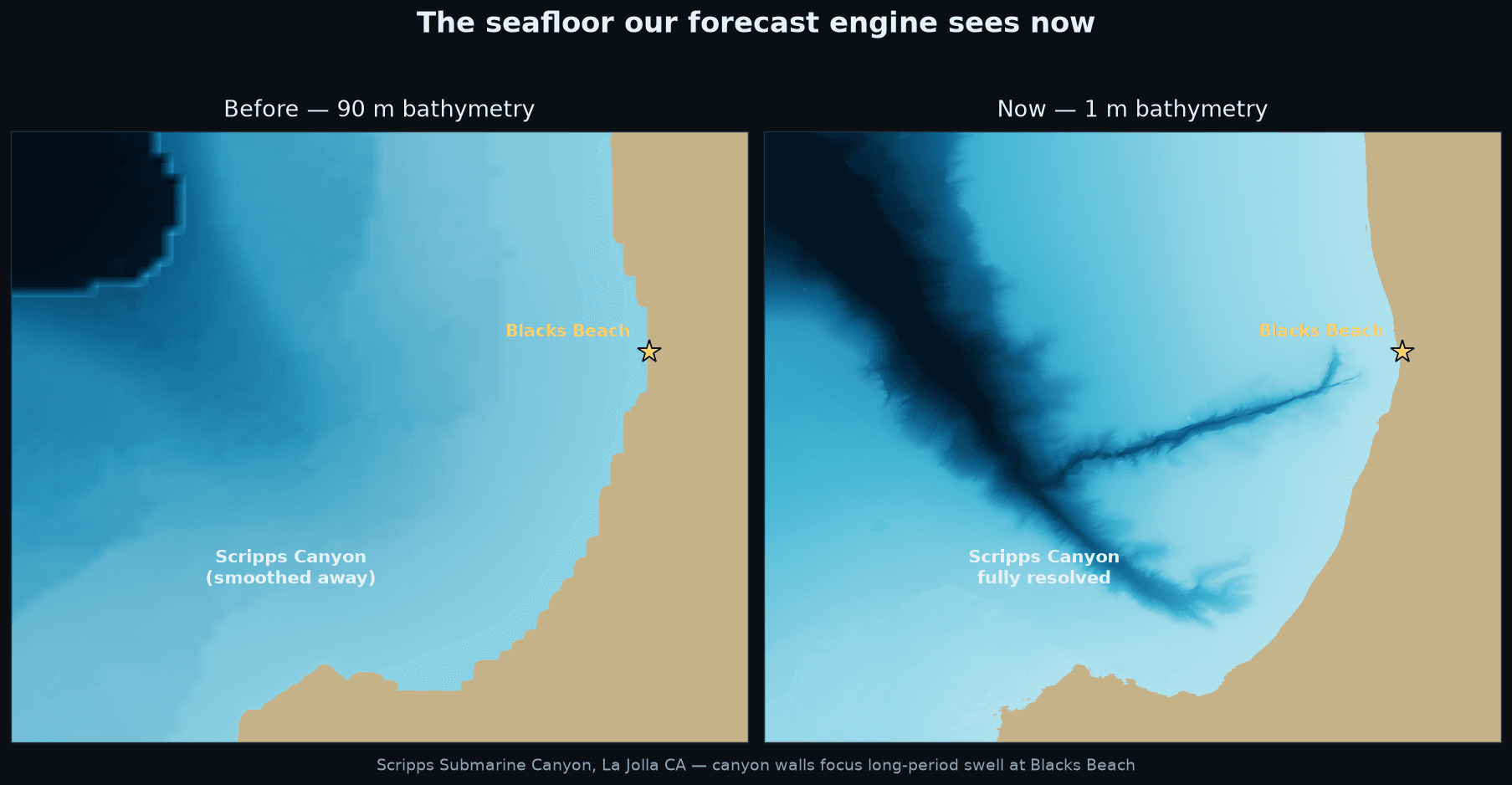
Some of the best waves in the world exist because of underwater terrain the size of a city block. Blacks Beach in San Diego is the classic example: Scripps Submarine Canyon runs almost to the sand, and its walls bend and focus long-period swell onto the beach — it is why Blacks is routinely bigger than every beach around it.
Our engine previously saw the ocean floor at roughly 90-meter resolution. At that scale, the canyon walls that create the magic at spots like Blacks are literally smoothed out of existence. We have now integrated NOAA's meter-scale coastal terrain surveys at canyon and focusing breaks — the image above is the actual before/after of what the engine sees at Scripps Canyon. Blacks and Scripps are live on the new seafloor now, with the Newport Beach canyon zone next in the queue.
Real shadow physics
Headlands, islands, and peninsulas cast swell shadows, and getting them right matters just as much as getting focusing right. We rebuilt our nearshore wave transforms across Santa Cruz and the Santa Barbara Channel on much larger physical domains, so the Monterey Peninsula, Point Lobos, and the Channel Islands now block and bend each swell direction exactly the way the real coastline does. The result: south swells at Santa Cruz points no longer read artificially small through the open window, and blocked directions go quiet the way they do in real life.
Every swell gets its own physics
Real surf is almost never one swell. A typical day mixes short-period local windsea with one or two long-period groundswells from storms thousands of miles away. The engine now transforms every swell train separately — each with its own direction, period, and shadow geometry — before combining them at the beach. In Puerto Rico this fix alone recovered one to two feet of trade-windsea surf that the old pipeline was filtering out twice on the island's north shore.
Anchored to measurements, not just models
Weather models drift. Ours gets pulled back to reality every single day:
More realistic set ranges
The gap between an average wave and a set wave is physics too. The engine now derives its set and lull range from wave-group statistics re-shoaled through each spot's own depth profile, and lifts storm peaks using the spread of a 30-member ensemble — so "occasional plus" days read like they feel in the water.
What's next
The queue never empties: the Newport canyon zone is rebuilding now, the Gulf of Maine's island sheltering is getting the same large-domain treatment as California, and we are replaying archived winter storms through every new table so the winter season is validated before it arrives — not after.
The forecast gets a little more honest every morning. That's the whole point.